
4 things to know about the weather:
- Cold wind blowing Tuesday
- Frost/freeze concerns Tuesday night
- Soaking rain on Friday
- Quite chilly this weekend
Our rainy Monday may have been a bit depressing but the rainfall was very beneficial.
Rain totals were generally in the 1/3" to 3/4" range and it came at a slow enough pace that the ground could soak it in rather than all of it ending up in storm drains. The Maryland side of the DMV remains in a severe, long-term drought while the Virginia side remains in moderate drought.
We've got the news you need to know to start your day. Sign up for the First & 4Most morning newsletter — delivered to your inbox daily. Sign up here.
Thankfully another soaking rain is coming - on Friday. But, first things first, you need to prepare for an unusually cold and windy Tuesday.
Cold wind chills Tuesday through Wednesday morning
Temperatures are as high this morning as they are going to get. Gusty and blustery northwest winds will arrive this morning and blow all the way into sunset. Temperatures will stay in the 40s all afternoon even with mostly sunny skies.
The strong, April sun will make a difference so stay on the sunny side of the street. In the shade, afternoon wind chills will remain in the mid-to-upper 30s! The wind will settle down quickly after sunset setting the stage for our coldest morning since early March.
Freeze warnings are already in place for all of the Delmarva Peninsula, Southern Maryland and the northern neck of Virginia. Temperatures on Wednesday morning will be right around 32° in Downtown D.C., along the Potomac and near the Bay. Everywhere else will drop below freezing so cold-sensitive plants will need to be protected.


Freeze threat Wednesday morning and more rain ahead
Sunny skies will lift temperatures above freezing by 9 a.m. and highs Wednesday will mainly reach the mid-50s. Clouds will return Wednesday night into Thursday and rain chances return by Thursday afternoon and evening.
Friday will be a washout. Steady rain is expected from sun up to sun down with higher rain totals than Monday. The I-81 corridor is likely to get around half an inch of rain while the I-95 corridor should be an inch or more. The rain will keep temperatures in the mid-50s all day.
Rain will taper off Saturday morning but the clouds will last well into the afternoon keeping highs in the low 50s. Sunday will have more sunshine and get close to 60°.
Weather radar
Download the NBC Washington app on iOS and Android to check the weather radar on the go.
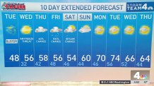
10-day forecast
Quickcast
TUESDAY:
Becoming Mostly Sunny
Blustery And Cold
Daytime Chills Around 35°
Wind: Northwest 18-32 mph
Chance Of Rain: 0%
HIGHS: 44° - 50°
TUESDAY NIGHT:
Clear Skies
Diminishing Wind
Frost/Freeze By Sunrise
Chance Of Rain: 0%
Wind: Northwest 5-15vmph
LOWS: 26° - 34°
WEDNESDAY:
AM Freeze For Many
Sunny Afternoon
Chilly
Chance Of Rain: 0%
Wind: West/Southwest 5 mph
HIGHS: 50° - 56°
THURSDAY:
Becoming Cloudy
Remaining Cool, Breezy
Few Showers After 3PM
Wind: Southeast 10-20 mph
Chance Of Rain: 40%
HIGHS: 54° - 58°
FRIDAY:
Cloudy, Cool & Rainy
Rainfall: 1/2" to 1"+
Heaviest Rain 6AM-6PM
Wind: East 8-16 mph
Chance Of Rain: 100%
HIGHS: 55° - 60°
Sunrise 6:42 Sunset 7:39
Average High: 65° Average Low: 46°